Discover Renwick
Renwick’s newer residential streets occupy part of a landscape with a long and sometimes painful history of institutional child welfare.
Explore nearby and connected places: Mittagong · Bowral · Willow Vale
Renwick through time
The cottage homes and farm homes
The Mittagong Cottage Homes began in 1885, initially using houses around Mittagong. A farm on the estate known in several sources as Southwood was leased in 1896. Later accounts differ about when the land was purchased: a 2024 council review calls it Southward and gives 1906; a 2021 heritage assessment gives 1907, while another conservation plan gives 1902. The underlying land records are needed to resolve the sequence and any separate acquisitions. The cottages, schooling and farm were part of the lives of children placed in state institutions, including children removed from their families.[3][13][14]
The history of the Mittagong Farm Homes is part of Renwick’s story. In 2010 Leonie Knapman presented a collection of period photographs showing the homes’ development over time; the Society’s report provides a lead for researchers seeking those images and associated accounts.[7][12]
The NSW State Archives agency history records that the Farm Home for Boys was proclaimed an industrial school in 1906 and opened that October as a probationary training home. Children aged eight to seventeen could be sent there under laws and classifications of the period, including for truancy, neglect or conduct labelled uncontrollable. Those official categories tell us how the state classified children; they do not describe the full circumstances of their lives.[8]
Later institutions and their records
One surviving cottage, the Renwick State Ward Home, opened in the early 1940s and remained in use until the institution closed in 1994, according to the NSW Government’s heritage-listing announcement. The later residential development has retained some physical reminders. Council’s Good Ja Gah Park preserves silos from the training-school period and explicitly commemorates the children confined there. This history calls for the experiences and recollections of former residents to be heard alongside the architectural record.[4][5]
The agency history records a change of name to Mittagong Training School for Boys in 1947 and the end of its training-centre role in 1976, when remaining boys were transferred elsewhere. A home for dependent children subsequently formed part of the centre named Renwick. These institutional changes should be read alongside former residents’ own accounts, including experiences not reflected in official reports.[8]
Find & Connect provides a starting point for former residents and families seeking the history of out-of-home care and records. Its archival photographs and descriptions include the former Turner Cottage school and a classroom at the Farm Home; they document particular moments and are not a complete account of children’s experiences.[9][10][11]
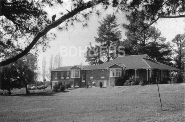
Related historical names and search terms: Mittagong Cottage Homes, Mittagong Farm Home. These may name a former settlement, institution or nearby feature; check the context in the sources.
Browse local photographs linked to Renwick
Explore the Society’s photographs for sale
Read the landscape
1838 holdings
View the annotated map on page 5 of the linked newsletter.
Rowe land holdings in Lower Mittagong: mapped interpretation
The annotated map is captioned as Thomas D. Rowe’s 1838 holdings but includes later place and estate labels. Treat the outlines as a retrospective interpretation, not a map necessarily made in 1838, and check grants and survey records for boundaries.
Related places: Mittagong, Renwick, Balaclava
Mapped interpretation reproduced in Society newsletter 538, June 2021, p.5; base map and annotation source not identified there.
View the newsletter; confirm the base map and annotation rights before reproduction.
Modern interpretation
View the plan on page 3 of the linked newsletter.
Lower Mittagong topographical plan
The drawn plan locates the old road, windmill site, Rowe’s cottage and other landscape features. It is a later interpretive drawing, not a contemporary nineteenth-century survey; consult the underlying evidence when locating individual features.
Related places: Mittagong, Renwick
I. V. Mackey, Lower Mittagong Topographical Plan, reproduced in Society newsletter 538, June 2021, p.3.
View in the Society newsletter; check the creator’s reproduction conditions before extracting the drawing.
Browse maps and plans linked to Renwick
Newsletter Mentions
Stories about Renwick in the Society’s newsletters.
January 2011
- The issue reports a display on Corbett Gardens and Tulip Time, and a presentation on Mittagong Farm Homes and Renwick (pp.3-4).
Books in our Library
These catalogue titles mention Renwick. Check the linked catalogue and ask the Society about access.
- School Centenary/Centenaries: Elmwood, Renwick, Sisters of St. Joseph and St. Michael's, Aylmerton, Avoca, Bundanoon, B - catalogue p. 53
Further research
There is more to discover about Renwick in the Society’s archives and in other collections. A catalogue entry may lead to material that has not been digitised or needs to be consulted in person.
- Ask the Society’s research centre about local files, photographs and records.
- State Library of NSW collections - search photographs, maps, manuscripts and local publications.
- NSW Historical Land Records Viewer - search historical land records, plans and parish maps by place or parcel.
Sources already connected with this place include:
- Council heritage review: Renwick, May 2024, p.110
- NSW Government: Renwick State Ward Home heritage announcement, 2014
- Wingecarribee Council: Good Ja Gah Park and the Renwick silos
- State Library of NSW: Find & Connect research resource
The Society can undertake professional research at $40 per hour. Contact the research centre to discuss your question and request a quote.