DP997354 - The Railway-Side Parcel
Moss Vale property history
The western triangle beside Whytes Corner
A small parcel between the railway side of the corner and the Arthur Street shopfront. Its present boundary is clear; assigning older buildings, owners and land transactions to that exact triangle needs more evidence.
The parcel today
- Land identifier
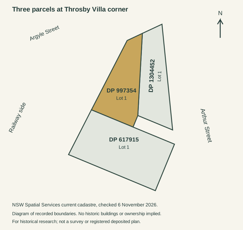
- Lot 1 DP997354
- Recorded area
- 951.822 square metres
- Precinct
- Argyle, Arthur and Throsby streets, Moss Vale
- Research basis
- Free records; original sources linked below
The highlighted outline comes from the present cadastral map. It identifies the land being researched; it does not date its buildings, identify an owner, or establish that the lot existed in this form in the nineteenth century.[6]
This is the western triangle in the supplied corner grouping, adjoining DP1304452 and DP617915. No street address or surviving building has yet been securely assigned to this exact outline by a registered plan.[6]
Land and ownership
This chronology separates records about the older estate and house from evidence tied to this present parcel. Gaps in registered ownership are left visible.
14 December 1872 House in the parent estate
Throsby Villa is documented
A birth notice records Oliver Spencer Throsby’s wife giving birth to a premature son at Throsby Villa. It securely dates the house’s existence, but supplies neither a construction date nor a modern parcel reference. The original Villa and the later shop or council chambers must be distinguished.[10]
30 September to 14 October 1882 Estate subdivision and sale
The estate becomes streets and allotments
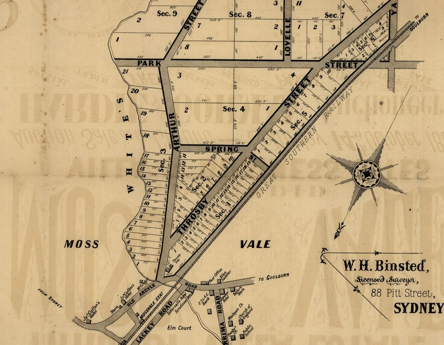
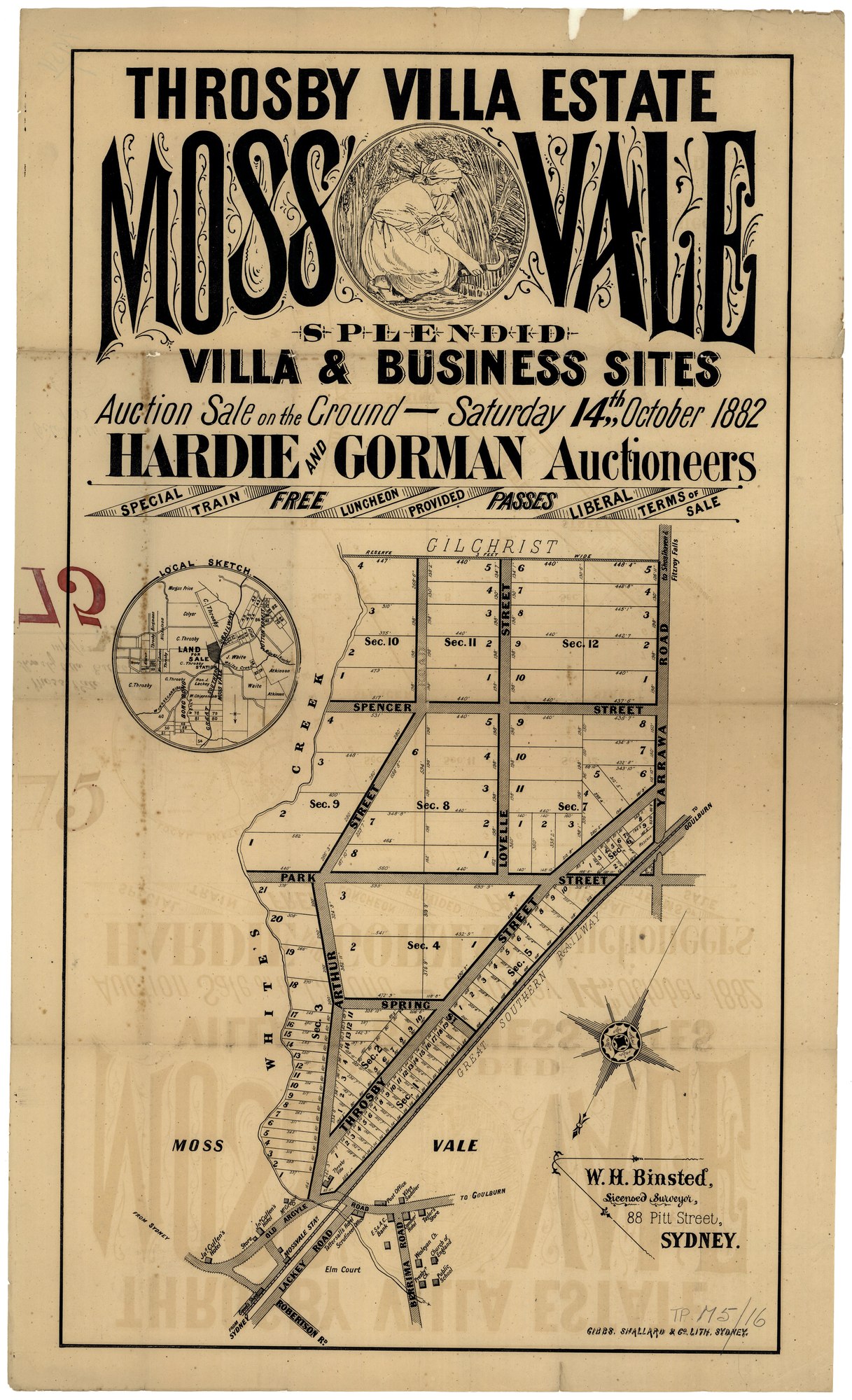
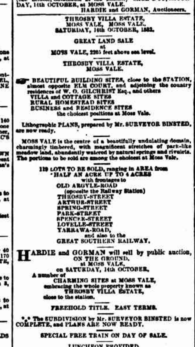
The 30 September advertisement offers 119 lots with frontages including Arthur Street. Binsted’s surviving poster advertises the 14 October auction and depicts the Villa near the railway, Old Argyle Road and Arthur Street. A report published on 16 October says Throsby Villa realised £750. It does not identify its purchaser. Historical Lot 1 and modern Lot 1 in each DP are separate systems of numbering.[8][7][9]
December 1886 Former Villa site
Fire ends the original house
The Goulburn Herald reports a fire starting in the detached kitchen and spreading through a covered passage. Members of the Light Horse helped remove furniture; Sergeant Crotty and J. Riley rescued three sleeping children. With little water or equipment, the house was destroyed. The report identifies Mr Lovell as its owner and describes its successive uses as a hotel, Throsby residence, bank, James Cullen’s rented family home and Lovell’s boarding establishment. These are reported building uses, not a complete registered ownership chain.[11]
2 February 1887 Former Villa site
The grounds return to the market
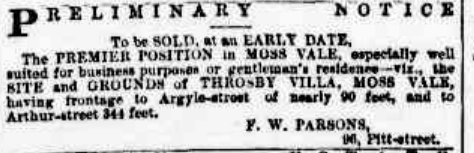
F. W. Parsons advertised the site and grounds of Throsby Villa as suitable for business or a gentleman’s residence. The stated frontages were nearly 90 feet to Argyle Street and 344 feet to Arthur Street, approximately 27.4 and 104.9 metres. This is a valuable geographic bridge after the fire, but the notice names no buyer and cannot alone allocate the land among today’s three DPs.[12]
People and premises
Land between the railway and the shops
The railway and the road junction are the stable landmarks through the surviving estate maps and the 1887 sale notice. They make this parcel part of an important historical setting, but they do not tell us which piece of a house, garden, yard or later commercial building stood within its present boundaries.[7][12]
The 1886 report gives the older house a sequence of occupants and uses: the Throsby family, a bank, James Cullen and Mr Lovell. Those names are useful search leads for the former Villa property. They are not yet a demonstrated list of owners of Lot 1 DP997354.[11]
Why the history has a visible gap
The current cadastre supplies a lot number, outline and recorded area. Searches of the free historical land-record index under the plan number did not recover a valid plan or title for this parcel. Numerical hits that belonged to unrelated document IDs were rejected. No registration date has been inferred from the DP number or GIS timestamps.[6][13]
Maps and photographs through time
Select an image to enlarge it. Captions identify its date, source and what it can establish.
What is still unresolved?
Which older deposited plan, deed or title was replaced by DP997354? Until that bridge is established, the Throsby Villa estate records remain parent-area evidence.
Was the triangle historically a separately occupied property, or a yard or access area used with adjoining premises? A present-day cadastral boundary does not answer that question.
How much of the Villa’s footprint, detached kitchen and garden lay here? The 1882 sale drawing is the best available visual starting point, but a measured alignment and earlier title schedules are still needed.[7][11]
Who was Arthur Street named for? The name is documented by 30 September 1882, but the naming decision and namesake have not been established. The poster’s presence of the name is not an explanation of its origin.[8][7]
Further research opportunities
Free records to pursue
- Compare the registered lot outlines with estate plans, HLRV charting maps and any surviving council survey or building-application drawings. A similar outline is a lead, not a substitute for a title reference.
- Consult the Society’s rate books, building records, photographs and local-history files. Recorded ratepayers may be owners or occupiers; retain the original column headings.
- Search Trove under business names, surname variants and changing street addresses. Earlier newspapers often omit house numbers, so a matching name alone is insufficient.
- Inspect State Archives NRS-8230, SR Map 6208, an undigitised Bong Bong parish manuscript catalogued approximately 1830s to 1850, if free reading-room access is available. Its coverage has not yet been verified.
- Extend the Newspapers.com searches through its local holdings using the verified business, owner and address variants. Initial browser searches and an inspected 1920 page produced unrelated page-level matches; this was not an exhaustive survey.
Paid documents that could close the gaps
- A current title search and registered deposited plan for this lot, followed by any prior-title search and earlier plans identified on them. No fee-bearing search has been ordered.
- The plan’s administration sheet and relevant transfers or primary-application packet, only after the free indexes identify the precise references. Confirm cost and availability before ordering.
Researched using free data and openly accessible historical records. Last reviewed 6 November 2026. Historical newspapers accessed through Trove, National Library of Australia. Copyright in credited third-party photographs remains with its owners.